Tornado, High-End Wind Risk Increasing Across Southern U.S.
- Andrew Pritchard

- Jan 7, 2024
- 3 min read
Updated: May 5, 2024
A lot of weather buzz has been centered on the winter storm risk associated with the storm system tracking through the eastern half of the U.S. early this week, but the dynamic storm will carry an associated severe weather risk in its warm sector.
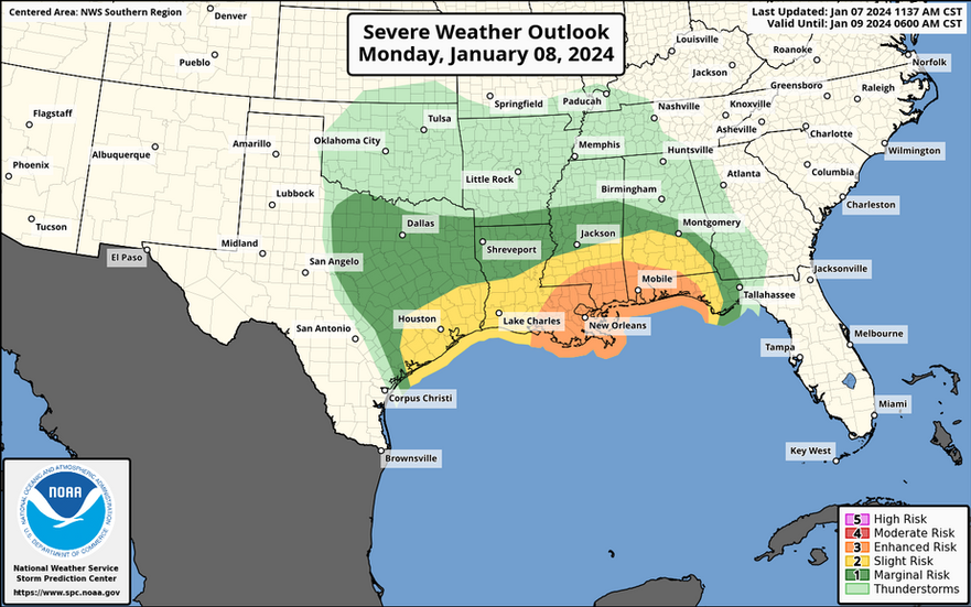
The risk begins along the Gulf Coast from eastern Texas to the Florida Panhandle on Monday and Monday night, expanding into Georgia and the Carolinas on Tuesday.
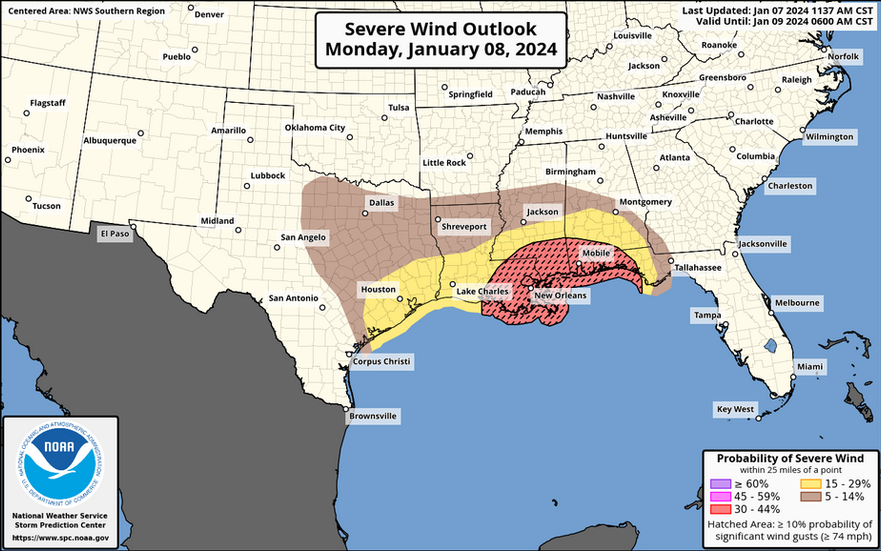
Strong forcing along the cold front may impose a linear storm mode on the majority of the event, but wind fields associated with this storm system will be high end which, even in the face of a mostly-linear storm mode could support embedded supercell thunderstorms and/or a QLCS tornado risk. Additionally, swaths of significant straight-line wind damage are possible with some of the stronger line segments.
Initially, isolated to scattered severe storms should develop across eastern Texas, moving into western Louisiana mid-day Monday. Some supercells with a risk for tornadoes are possible here in this initial period.
18z SUN HRRR valid 18z MON [That's 12 PM CT on Monday]:

Overnight Monday into Tuesday morning storms likely organize into a squall line with a risk for severe winds and isolated tornadoes throughout the line. Additional storms ahead of the line associated with the lifting warm front and warm air advection regime (as modeled by the HRRR below) are a possibility, but a less certain aspect of the overnight period. These warm air advection driven storms can be prolific lightning producers.
18z SUN HRRR valid 6z TUE [That's 12 AM CT on Tuesday]:

Through the day on Tuesday I think we may be watching a high-end severe weather event in the form of a kinky line of storms riddled with embedded tornado potential and wind gusts exceeding 70 MPH.
18z SUN HRRR valid 15z Tue [That's 9 AM CT on Tuesday]:

Check out the big, loopy hodograph on this forecast sounding from the 18z Sunday HRRR. Even in a predominantly linear event, I agree with the Storm Prediction Center's desire to introduce stronger wording to their latest severe weather outlooks surrounding the potential for embedded tornadoes and significant wind damage.

From a societal impact standpoint this storm has all the makings of a disruptive, high-impact event. Strong synoptic winds and the added potential for significant severe winds means there's potential for widespread power outages from the Midwest into the Southeast U.S.
Folks in the Midwest will be shoveling snow for the first time this season, while our neighbors to the South may be headed for storm shelters.
Plenty to discuss in the coming week...
Here's what the Storm Prediction Center is saying ahead of Monday & Tuesday's storms:
TWO ROUNDS OF STRONG TO SEVERE THUNDERSTORMS ARE POSSIBLE ACROSS THE REGION MONDAY, WITH THE FIRST ROUND LIKELY BEGINNING EARLY MONDAY AFTERNOON AS THE WARM SECTOR MOVES INTO THE REGION. CURRENT GUIDANCE SUGGESTS THIS WARM SECTOR WILL BE CHARACTERIZED BY TEMPERATURES IN THE LOW 70S, DEWPOINTS IN THE UPPER 60S, AND MODERATE BUOYANCY. HOWEVER, GIVEN THE PREVALENCE OF CLOUD COVER AND EARLY PERIOD SHOWERS, THERE IS UNCERTAINTY REGARDING IF TEMPERATURES CAN REACH THE LOW 70S. IF THEY DO, SOME SURFACE-BASED SUPERCELLS CAPABLE OF ALL SEVERE HAZARDS, INCLUDING TORNADOES ARE POSSIBLE. IF TEMPERATURES STAY IN THE 60S, LOW-LEVEL STABILITY WOULD LIKELY INHIBIT SURFACE-BASED STORM DEVELOPMENT, MITIGATING THE SEVERE POTENTIAL. CONSENSUS WITHIN THE GUIDANCE HAS TRENDED TOWARDS WARMER TEMPERATURES AND TORNADO PROBABILITIES WERE INCREASED ACROSS THE REGION AS A RESULT. A FURTHER INCREASE IN PROBABILITIES MAY BE NEEDED IN LATER OUTLOOKS IF CONFIDENCE IN SURFACE-BASED STORMS INCREASES. GENERAL EXPECTATION IS THAT A FAST-MOVING, WELL-ORGANIZED CONVECTIVE LINE WILL BE ONGOING AT THE BEGINNING OF THE PERIOD ACROSS THE WESTERN FL PANHANDLE AND SOUTHEAST AL. ROBUST KINEMATIC FIELDS SUGGEST THAT STRONG GUSTS ARE LIKELY WITHIN THIS LINE. ADDITIONALLY, LARGE, LOOPING LOW-LEVEL HODOGRAPHS INDICATE THERE IS POSSIBILITY FOR LINE-EMBEDDED QLCS TORNADOES AS WELL. WITH THE MID-LATITUDE CYCLONE (AND ASSOCIATED LARGE-SCALE ASCENT) BECOMING INCREASINGLY DISPLACED TO THE NORTH, RELATIVELY WARM MID-LEVEL TEMPERATURES DOWNSTREAM ACROSS NORTHERN FL AND SOUTHERN GA ARE CURRENTLY EXPECTED TO LEAD TO SOME DECREASE IN THE INTENSITY OF THE LINE AS IT CONTINUES EASTWARD. 


