
Chase Log: March 10th Tornadic Supercell in Northeast Illinois
- Andrew Pritchard

- Mar 14
- 5 min read
This will always be a complicated chase to look back on I think, parts of it were perfect, parts of it were perplexing.
There was a lot of hype in the days leading up to March 10th, but I had a pretty busy day planned and wasn't even sure how much I'd get out and document myself. I wound up getting through my to-do list by Noon and was able to get packed up and moving but somewhere in the last 24 hours I'd picked up a nail in my front right tire that was slowly leaking but mostly holding its own. There were definitely a couple brain cells that were telling me to just leave town and monitor my tire pressure, filling it up periodically if needed and hope for the best, but looking at the latest high resolution guidance I knew there was no way I was late or in any way needing to rush things along and to do the right thing and get the tire patched and repaired.
There were two targets in play, an east zone in northeast Illinois and northwest Indiana that could go in the late afternoon, or a west zone that was expected to erupt closer to sunset. The east zone target was only one hour away to my north, so even if the tire situation took 2+ hours I'd still be able to leave and get there in time for storm development. If the west zone was the only play, it was a little further away but still only 2 hours or so, and if it went up around 6 PM as expected that also meant the tire repair could take 3-4+ hour and I'd be fine.
Everything went as hoped, quick patch and repair that took maybe 30 minutes and I was finally free to get into storm observation mode by around 1 PM or so. I ended up just taking the opportunity to look at data one last time in the waiting room and decided for sure that I was heading for the east target for now. The repair shop gave me the nail they pulled from my tire - it was HUGE:

I targeted Dwight, IL and drove up Highway 47 which is a favorite local highway of mine. As I got closer to Dwight it seemed everyone including my chase partner Colin Davis was hanging out at the Wally's truck stop in Pontiac. This was like 10 minutes from my target in Dwight so I figured it wouldn't make a big difference in my positioning for the day and I was feeling social for once in my life so I ventured over that way to hang with everyone.
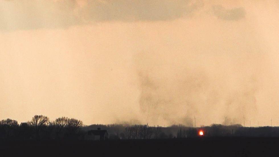
We watched the eventual storm of the day develop to our southwest from a towering cumulus cloud, to a thunderstorm, to a full-on supercell thunderstorm that was rotating and lowering just to the west of us in Pontiac, all without ever leaving the Wally's parking lot.
Colin and I departed as the storm started ramping up in the lower levels and went east of town, immediately documenting a brief tornado touchdown on the outskirts of Pontiac. To this point, we're on track for one of the best chase days ever. Targeting perfect, watching the storm go up and mature without even moving, and then getting it to produce a tornado essentially on its first attempt... that's a crazy desirable start to any chase day.


That's when things got wonky. I think part of the problem here actually was the fact the storm looked SO GOOD right away at Pontiac. Crazy structure, really textbook rotating wall cloud that looked like it was going to produce a significant tornado. So mentally you're like, it's only up from here, this storm is going to be NUTS. And then for the next hour it looks kinda, basic. A little cold, a little high based, still rotating but not very hard and not with any sort of rising motion.
Models had hinted at times that one issue with this east zone could be storms erupting, going for 1-2 hours, and then dying as they crossed the warm front into the cold air. Is this what's happening?
For an hour we followed this storm toward Kankakee but then that idea of a sunset tornado from round 2 to the west started creeping in. Is this storm letting us off the hook and dying early so we can retreat west and be there in time for the evening round?
Eventually this idea won out and west we went. The one thing that really bugs me still as I write this just 5 days later is that the drive west was not toward anything. You still had a viable tornado-warned supercell in front of you over by Kankakee. It was struggling yes, but when you have a struggling supercell in front of you, and NOTHING to your west, maybe stick with the supercell next time.
Because in the end, what, I was leaving this ongoing Kankakee storm because I was afraid it was turning into a hail-only supercell on the cold side of the boundary. And what did round 2 predominantly end up being? Hail-only supercells on the cold side of the boundary? All I did was leave this problem only to drive 2 hours west to the same problem, while the east storm righted itself and reorganized into a storm that will etch its place into the Illinois record books after producing a state record 6" diameter hailstone and an EF-3 tornado that tracked for over one hour from Kankakee into Indiana.
My chase ended on Interstate 39. I initially targeted a lead tornado-warned storm headed for Tonica, IL but as I drove north on 39 to get in front of it the temperature on my dash dropped from like 72 degrees to 53 degrees. Wrong side of the boundary! I ended up running into the Casey's there in Tonica to grab some pizza and a coke and went north of town to watch some lightning and eat my dinner and think about what I'd done.
Another tornado warned storm was approaching I-39 to my south near Wenona and I figured this one might at least be on the right side of the boundary. The low-level jet was kicking in and wind shear was supposed to become more favorable for tornadoes in the overnight so I didn't want to just completely check out and screw up a chance to do something about a tornado that might hypothetically cross Interstate 39 down there by Wenona, only about 10 miles back to my south.
Driving south on 39 I crossed the boundary in what was actually pretty jarring fashion. You could hear and feel the sudden wind shift and all of my windows immediately fogged up as I went back from low 50s temps into low 70s temps. I got off of Interstate 39 at the Wenona exit and decided to just have a relaxing time watching the vivid lightning from this storm illuminating the updraft and upstream forward flank downdraft.
This was one of those moments where I was just happy to be staring at a lightning show, listening to rumbling thunder, and enjoying a warm south wind after a long winter. Presumably there should be an entire season ahead, and I'm just grateful for a pair of really enjoyable opportunities to document and observed tornadic supercells in Illinois back on Feb 19th and again on March 10th.


The pattern looks pretty quiet in the near-term except for this potential Mid-South/Ohio Valley QLCS tomorrow (March 15th). Not sure it'll drag me out the door unless I think I've got a somewhat easy opportunity to pick off some significant winds or an embedded circulation coming up to Interstate 57 off to my south or something. Otherwise, looks briefly cold and then boring in the-near term through mid-March.


