
BOOM or BUST Storm Observation Opportunity Today


Another one of those days that I'm sitting at the forecast desk feeling like today is a storm observation day, perhaps even one that could end with a supercell and tornado observation, but I've got very little idea when I'd be leaving Champaign-Urbana and what direction I'd be going.
Short-range model guidance hasn't proven very helpful over the last 24 hours leading up to today, the first in a series of days with similar severe storm risks painted across the Northern Plains and Midwest, typical of this time of year. Lots of instability and storm fuel, and tons of little boundaries and subtle jet stream waves that could either help or hinder storm development through the day. The HRRR has leaned in the direction of a capped environment and poorly timed wave with little happening until later tonight, while the 3km NAM pops a cluster of supercells in northern Illinois this evening. It could be either or neither.
Time it right and you've got a vorticity rich little wave swirling into an extremely unstable environment which can lead to a localized environment favorable for significant severe storms, or time it right and you've got a wave floating through mixed out, capped air from an earlier wave/round of rain and storms.
That's the question today. There's a lot going on when looking at current surface conditions and satellite imagery. A lead wave has an intense area of storms ongoing in southern Wisconsin with a trailing outflow boundary that does have some agitated cu along it. Honestly, the environment out ahead of all that across northern Illinois into northwest Indiana is really priming, and you could get a continuance of ongoing storms with new storms erupting along the trailing outflow. This usually results in back-building, mostly outflow dominant storms, but as I observed on July 27th you can also end up with a rather long-lived supercell riding that well established boundary with a risk of tornadoes.
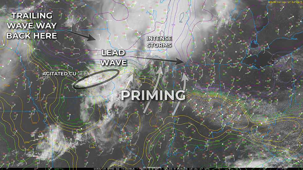
Perhaps more enticing for a late-evening storm observation however, is the idea that this lead wave could leave an outflow boundary across northern Illinois. In the vicinity of that boundary, the afternoon sun could prime the air mass once again leading to strong to extreme instability along a boundary with tons of spin along it. With the right amount of insolation (sunshine!) and air mass recovery, you can suddenly end up with a volatile environment favorable for supercells. You can also just end up with a capped environment that stays completely quiet until the low-level jet ramps up and nocturnal storms erupt across the area.
Both targets are about 2-3 hours away from home base, so for now I'm doing some Sunday chores while sipping a third cup of coffee. Mentally I kind of see myself heading out around 2 PM, either drifting north toward the junctions of I-39 and I-80 or I-88 in northern Illinois for that boom or bust scenario in northern Illinois, or perhaps following ongoing action north-northeast into far northeast Illinois or northern Indiana.
To be determined...

