
Jamaica Braces for Cat 5 Hurricane Melissa Today
- Andrew Pritchard

- Oct 28, 2025
- 2 min read

As of early Tuesday morning, the storm was parked just southwest of Jamaica, packing sustained winds of 175 mph (280 km/h) and a central pressure of 901 mb. With a tight 10-nautical-mile eye surrounded by an intensely cold cloud-top ring (-80°C and colder), the structure screams “major disaster incoming.”
The island of Jamaica is already feeling tropical-storm conditions, but the worst is still ahead. Catastrophic hurricane-force winds are expected today, especially near the centre path and in elevated terrain where gusts may be 30% stronger than over flat land.
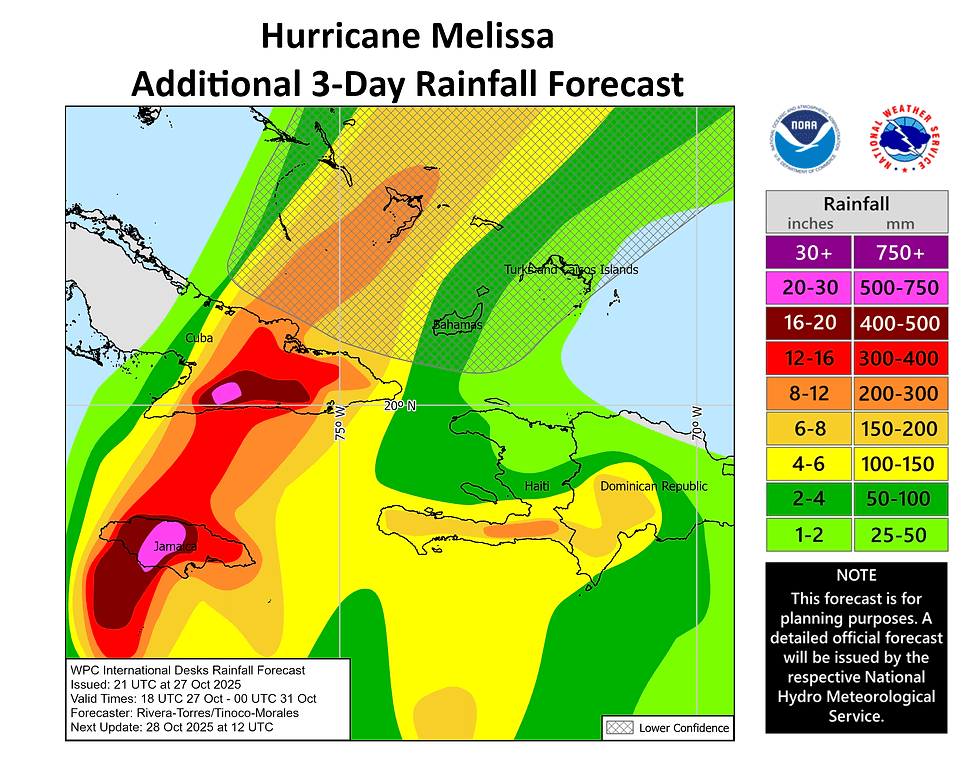
Rainfall total will be extremely heavy, 15 to 30 inches in many areas, with local amounts reaching 40 inches in some spots. That kind of deluge means flash flooding and landslides will be widespread and like destructive.
Storm surge along Jamaica’s south coast could reach 9 to 13 feet above ground level near and east of where Melissa makes landfall. That’s a life-threatening amount of inundation plus destructive waves. On the northwest coast, near Montego Bay, even 2-4 feet is possible.
After Jamaica is impacted, Melissa is expected to move over eastern Cuba Wednesday morning and then into the southeastern or central Bahamas later on. Impacts in these areas will include heavy rain, flooding, landslides, and life-threatening surge and wind. The storm will eventually accelerate northeast and interact with higher-latitude shear and cooler waters, gradually transitioning to a broader, asymmetric wind field.

This is a high-end, extremely dangerous hurricane targeting populated island terrain. Between the violent winds, devastating rainfall, and massive storm surge, Jamaica (and then Cuba and the Bahamas) are in the crosshairs of a one-two-three punch of hazards.

For more information from folks who are a lot smarter at tropical hazards than I am, check out Levi Cowan's blog here: https://www.tropicaltidbits.com/
National Hurricane Center: https://www.nhc.noaa.gov/

